воскресенье, 9 сентября 2012 г.
Aral Sea
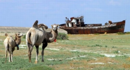
It would seem that, until quite recently, Lake Aral Sea was the fourth largest in the world. Its area was 68 thousand square meters. km., and the depth of 10-17 meters, the highest - 54.5 m in its waters, there were about 300 islands, the largest - Barsakelmes and Renaissance. The sea itself and the Aral Sea area were considered thriving with rich natural and biological environment. The Aral Sea has been serving huge evaporator. Of it evaporates and enters the atmosphere over 60 cubic km of water per year, a coastal climate is mild, despite the proximity of the desert. Today, the fate of the Aral Sea may serve as an excellent illustration of human stupidity and ignorance.
 The Aral Sea is an internal salt water without water flow, it eats (or rather eat) the waters of two rivers, the Amu Darya and Syr Darya. That fresh water these two giant arteries maintain the water level and sea-salt balance of the lake.
In the early 60's of the last century, the Soviet government guided by the idea of maintaining the image of a "superpower" decides to significantly increase the cultivation of cotton and rice, the place came as Aral Sea region. Arid, semi-desert and not cool the hot heads of party bosses, water for irrigation, it was decided to take the two rivers Amu Darya and Syr Darya.
The Aral Sea is an internal salt water without water flow, it eats (or rather eat) the waters of two rivers, the Amu Darya and Syr Darya. That fresh water these two giant arteries maintain the water level and sea-salt balance of the lake.
In the early 60's of the last century, the Soviet government guided by the idea of maintaining the image of a "superpower" decides to significantly increase the cultivation of cotton and rice, the place came as Aral Sea region. Arid, semi-desert and not cool the hot heads of party bosses, water for irrigation, it was decided to take the two rivers Amu Darya and Syr Darya.
Подписаться на:
Комментарии к сообщению (Atom)
Комментариев нет:
Отправить комментарий